Best Yosemite National Park Hikes off HWY 120 from Hwy 395
Yosemite National Park – East Entrance – Dreaming of a Yosemite adventure, but short on time? Look no further than the park’s eastern entrance, accessible from Carson City in under 3 hours! Here, you’ll find a treasure trove of day hikes offering stunning scenery, diverse landscapes, and unforgettable experiences. Lace up your boots and embark on a journey through towering pines, granite giants, and shimmering alpine lakes.
Traveling from the East side of Yosemite National Park is only available seasonally. However when it is open the Eastern Sierra Communities have tremendous access to some of Yosemite National Parks best day hiking experiences.
Sierra Rec, in the Summer of 2014 explored this eastern edge of Yosemite National Park, looking for the best day hike opportunities for people traveling from the Carson City / Reno region. The idea being that a family or individual could leave early in the morning drive no further than 3 hours and hike all day only to return that evening after a great day hike.
Here our 10 top hikes to consider this season as you look to Yosemite National Park for family adventure.
Cathedral Lakes: A Majestic Panorama (7 miles, 1000ft elevation gain) 4 to 6 hours
This classic hike rewards with breathtaking views of Upper and Lower Cathedral Lakes, framed by towering granite peaks. The steady climb is well worth the effort, offering panoramic vistas of the surrounding Sierra Nevada.
- Roadside Parking is discouraged after a roadside bumper was placed in 2022. New Parking lots have been added before the trailhead. Adding approx. a half mile to your trip.
- Cathedral Lakes trail accesses both Lower Cathedral Lake and Upper Cathedral Lake. Our advice is to travel to the upper Lake first, traverse the granite shelf that stands between the lakes and enjoy one of the great High Sierra view points, easily accessed by most visitors.
- Upper Cathedral Lake is know as a great back country fishing location.
- Access to Cathedral Peak Hikes. Climbers love to connect with Yosemite in this unique peak experience, often traversing Cathedral Peaks and Echo peaks on the same trip.

Cathedral Lakes trailhead, 1/2 mile west of the Tuolumne Meadows Visitor Center, Shuttle Stop #7 The trail climbs steadily to Upper Cathedral Lake with sections of Switchbacks near the middle that will test most hikers. Bring water and snacks, the trail is forested the entire way with plenty of places to rest.
Near the top of the climb, the new spur trail to Lower Cathedral Lake will exit West ( 1 mile to lake). The return hike follows the same route. The Upper Lake is approx. 1 mile further and will climb a little further over a foothill and around a meadow section. You will pass the old trail exiting West to Lower Cathedral along the way, this route is no considered closed as the meadow is in rehabilitation state and is often muddy and mosquito infested. Highly recommend the new route to Lower Lake.
This is one of the busiest trails in the Tuolumne Meadows area so expect many fellow hikers, backpackers and Thru hikers of the JMT heading around the Cathedral Crest to Lyell Canyon. If you are looking for a little seclusion on this trail, you might consider passing the Upper cathedral Lake and following the JMT trail up above to a large meadow typically filled with wildflowers. If you are good at navigating and proceed off trail around the rim of this meadow it will eventually lead to Echo Lakes and a stunning granite rimmed meadow below Echo Peak. ( A personal Favorite of our at the magazine)
Since parking at the trailhead is limited, consider taking the free shuttle bus.
Elizabeth Lake: A Serene Escape (4.8 miles, 1000ft elevation gain)
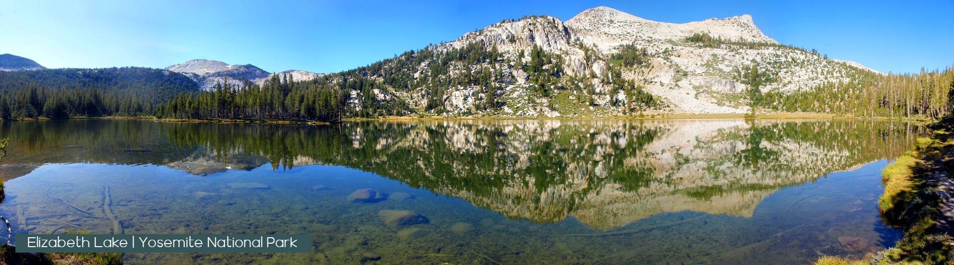
Nestled at the base of Unicorn Peak, Elizabeth Lake is a tranquil gem perfect for a peaceful escape. Hike through towering pines and meadows bursting with wildflowers, culminating in a serene lakeside haven. A great locations for fishing, wildlife viewing and relaxing secluded experiences in Yosemite. Begin at Tuolumne Meadows Campground near group camp.
The trail begins in the B loop of the campground and climbs steadily to a glacier-carved lake at the base of Unicorn Peak. Unicorn Creek flows East / North East out of Elizabeth Lake and the trail will give you options to cross it jut prior to the Lake. s the early summer its rush down towards the Tuolumne meadow is a refreshing sound in this tree lined forested climb. The waters along the bas of Unicorn peak are deeper and perhaps more welcoming for a swim.
There is no camping or backpacking at Elizabeth lake, but backpackers will be seen on this trail as part of a off trail experience past Elizabeth lake that leads to Nelson Lake or Matthes Lake.
The return hike follows the same route.
Gaylor Lakes: High Country Views (2 miles, 500ft elevation gain)

For panoramic vistas without the crowds, head to Gaylor Lakes. This short hike ascends to a ridge boasting breathtaking views of Mt. Dana, Dana Meadows, and the High Sierra wilderness.
Begin at Tioga Pass Entrance Station. (Free shuttle service is available twice per day.)
This hike offers some of the most spectacular high-country views off of Tioga Road. From the trailhead, climb steadily to a ridge with views of the high Sierra including Mt. Dana and Dana Meadows with its scattered ponds. At the ridge crest, the trail drops 200 feet to Middle Gaylor Lake.
The largest Gaylor Lake is set at the base of the trail and acts as a type of infinity pool as its western edge disappears into the Cathedral Range on a clear day. A short hike East and up the hill leads to the Upper Gaylor lake, a much smaller and shallower lake, most visitors hear are headed up to the old mine history further up the hill.
Directly North of Gaylor lake there is no official trail but head towards the Sharp Granite wall and discover one of Sierra Rec magazines favorite get aways Granite Lakes
Return via the same route.
Glen Aulin: A Waterfall Wonderland (11 miles, 800ft elevation gain)
Follow the cascading Tuolumne River to Glen Aulin, a hidden gem showcasing a series of waterfalls. Witness the power of Tuolumne Fall and White Cascade, or venture further to discover California Fall, LeConte Fall, and Waterwheel Falls.
This is in our opinion one of the top 10 Hikes in all the Sierra. Early summer or Late spring, when ever Tioga Road opens for the season, this would be my first visit. In some ways the waterfalls on this route, although not as tall as Yosemite Valley, they certainly hold their own for beauty, uniqueness and raw power as the rivers rips towards the Grand Canyon of Yosemite.
The first 4-5 miles of this hike are flat and follow the stunning Tuolumne River with panoramic views of the Cathedral range to the south all day. Wildlife is abundant on this route and fisherman can be found along the banks the entire route spread out enjoying their own magical life in Yosemite high country.
Of Course the backpacking community is well aware of the Glen Aulin High Camp Experience that connects this part of the park with May Lake, Sunrise Lakes and Vogelsang Lakes in one of the great Sierra Adventures of all time.
Follow the Tuolumne River as it drops to Glen Aulin. Tuolumne Fall and White Cascade are four miles from the trailhead. Beyond Glen Aulin are California Fall (13 miles round trip), LeConte Fall (15 miles roundtrip), and Waterwheel Falls (18 miles round trip). The return hike follows the same route.
Kuna Creek Cascades & Lyell Canyon: A Canyon Adventure (8 miles, 200ft elevation gain)
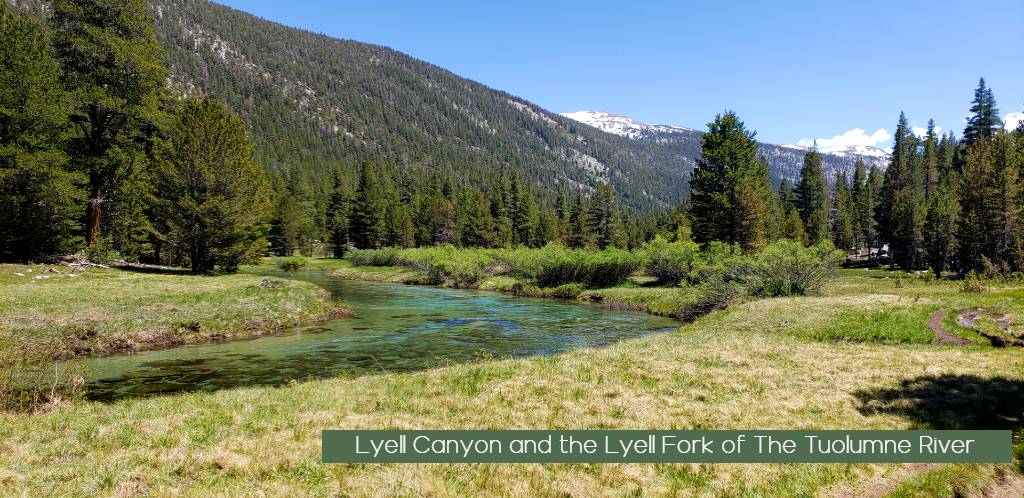
Delve into the heart of Lyell Canyon on this exciting hike. Traverse along the Lyell Fork of the Tuolumne River, encountering seasonal wildflowers, granite domes, and the mesmerizing Kuna Creek Cascades. Lyell Canyon is a stunning location in Yosemite and a great casual hike fit for all explorers.
Begin across the road from the Dog Lake parking area (shuttle stop #2) near the Yosemite Wilderness Permit station.
This trail passes through Lyell Canyon, along the Lyell Fork of the Tuolumne River. Early in the season, the trail can be muddy in places (please remain on the trail even if it’s muddy). There are several creek crossings, including Rafferty Creek (bridged) and Ireland Creek (unbridged). Spectacular Kuna Creek cascades down the side of the east canyon wall near the eight-mile mark.
For a shorter trip, walk 1/2 hour each way to the Lyell Fork and “Twin Bridges.”
Wildflowers, Wildlife and stunning Glacier Carved Valley Walls on both sides of the river. Spend a day on a rather easy stroll as the river veers and peaks its way to and from the trail. fishing is popular along its banks and a the cold crisp water is a welcoming swim on a hot summer day in the valley. this part of Yosemite is where the PCT comes through so seeing thru hikers on the PCT in summer is common.
Harden Lake: A Tranquil Oasis (5.8 miles, 355ft elevation gain)
Hike alongside the Middle Fork of the Tuolumne River on this peaceful journey to secluded Harden Lake. Immerse yourself in a world of towering pines, granite domes, and a vibrant aspen grove (especially stunning in early fall).
Hike along a gravel road—part of the original Tioga Road—that follows the Middle Fork of the Tuolumne River for part of the route. At a trail junction 1.75 miles (2.8 km) down the road, follow the signs to the lake. The trail passes by small granite domes and through a forest of red fir and lodgepole pine to reach boulder-dotted Harden Lake.
Optional loop to the edge of the Grand Canyon of the Tuolumne River. 8.4 miles (13.5 km) loop. 1,000-foot (305-m) elevation gain on the return trip. 5-8 hours.
Beyond Harden Lake, descend into a large aspen grove full of seasonal flowers, which can be wet and muddy until early August. At the next trail junction, 1.3 miles (2 km) from Harden Lake, turn south towards Lukens Lake and continue towards the White Wolf junction for 2.7 miles (4.3 km). Follow the trail 0.8 miles (1.3 km) back to White Wolf Lodge.
May Lake: A Half Dome Panorama (2.4 miles, 485ft elevation gain)
Enjoy postcard-perfect views of Half Dome and the surrounding mountains on this short and scenic hike to May Lake. The granite slabs and conifer forest create a picturesque setting, perfect for a leisurely stroll or a picnic lunch.
Begin at the May Lake parking area, 1.75 miles (2.8 km) north of Tioga Road. The parking area is located just West of Olmsted Point and travel North up along a meadow and creek following the old highway path of Tioga Road.
A short trail leads through a conifer forest and across granite slabs to reach May Lake. Enjoy views of Half Dome and surrounding mountains on the way. (warning Mosquitos can be a tad aggressive at this beautiful lake)
May Lake is also part of the High Sierra Camp loop and in the summer backpackers can stay at the lake with camp amenities such as bathrooms and a cooked meal. The ridge North of the Lake is a stunning location to watch sunrise over the Cathedral range and most visitors head West and up to tackle the climb to the top of Mt Hoffman, know as one of the best views in all of Yosemite National Park. (Mr. Hoffman was a park ranger in Yosemite and the story goes, that May Lake was named after a special lady friend that traveled to the lake for an afternoon picnic with Mr. Hoffmann)
North Dome: Challenge the Summit (10.4 miles, 580ft elevation gain)
For experienced hikers seeking a thrill, North Dome offers an unforgettable challenge. Not to be mistaken as a task as great as Half Dome its cross canyon neighbor, North dome hold its own brand of Hiker Torture for travelers willing to go all the way. Hike through diverse forests, meadows, and granite landscapes before embarking on North domes decent and rise as the dome comes to rest at the cliffs of Yosemite Valley face to Face with Half Dome. Be rewarded with jaw-dropping panoramas of Half Dome and Yosemite Valley.
the Torture of this stunning hike is in the return. If you have challenged your self in dropping down 700 feet to North dome from the trails peak near Indian Arch, you now face a slog of a climb back up the trail in the hot summer heat. It hurts, but it is so worth the view!

Begin at Porcupine Creek Trailhead on Tioga Road, 1.2 miles (1.9 km) east of Porcupine Flat Campground
Wind through mixed-conifer forest for 0.7 miles (1 km) on a paved path, and cross Porcupine Creek. At each of several trail junctions, follow the signs toward North Dome. The trail passes through a small grassy meadow and descends along a ridge. Near the end of the hike, descend steep rock steps to the base of North Dome. Climb the dome’s rounded summit to take in a magnificent view of Half Dome and Yosemite Valley. On the return trip you can take a short detour on a side trail, 0.3 mile (0.5 km) to an unusual natural arch, Indian Rock.
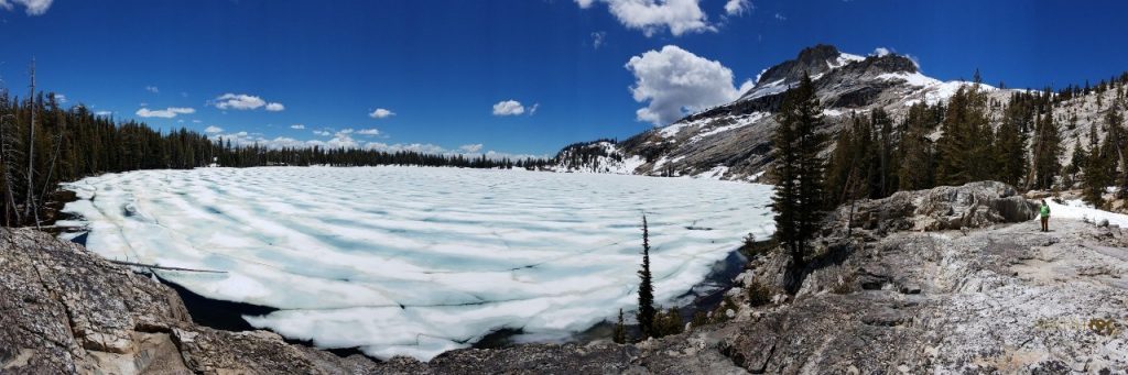
Sunrise Lakes & Clouds Rest: Hike Among the Clouds (7 miles to Clouds Rest, shorter options available)
Embark on an epic adventure to Sunrise Lakes or Clouds Rest, offering unparalleled views of the surrounding wilderness. Choose from various loop options, including iconic destinations like Merced Lake, Half Dome, or Cathedral Lakes.
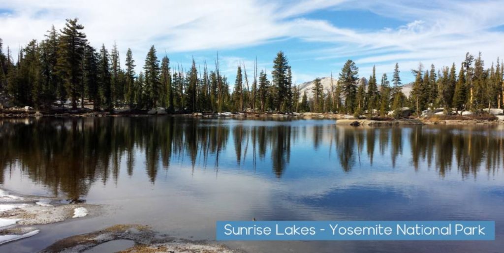
Sunrise Lakes 3.3 mi / 6.6 mi round trip – This trail departs from western Tenaya Lake and follows switchbacks up toward Sunrise Lakes or Clouds Rest. Clouds rest is well known achievement in Yosemite as it is one of the few routes that allows visitors to look down on Half Dome. Sunrise Lakes along the way is another stage of the High Sierra Camp route in Yosemite and the lakes provide a nice retreat from the trail crowds at times during the summer season.
Visitors can choose from several different loop options in this area such as Merced Lake, Half Dome, or Cathedral Lakes.
Ten Lakes: A Basin of Beauty (12.6 miles, 2200ft elevation gain)
For a true wilderness experience, tackle the Ten Lakes Trail. Hike through diverse landscapes, conquer Ten Lakes Pass with its breathtaking vistas, and descend into a basin teeming with sparkling alpine lakes.
Begin at Ten Lakes Trailhead, across Tioga Road from Yosemite Creek Picnic Area
Follow this trail through conifers and across granite to cross a tributary of Yosemite Creek. Take care on this crossing early in the season when the creek is high. Continue on the trail to Ten Lakes Pass, overlooking the Grand Canyon of the Tuolumne and the Sierra Crest. Then descend 693 feet (211 m) into the Ten Lakes Basin, which contains a series of beautiful High Sierra lakes. Grant Lakes is at the end of a 1-mile (1.6-km) side trail from the pass.
Mono Pass Trailhead: Gateway to Ansel Adams Wilderness (7.2 miles, 1600ft elevation gain)
Step into the realm of renowned photographer Ansel Adams on this moderate-to-strenuous hike. Starting from the Mono Pass Trailhead, traverse through subalpine meadows brimming with wildflowers and towering granite peaks. As you ascend, be mesmerized by panoramic views of the Sierra Nevada, including Ritter Pass, Mono Lake, and the Ansel Adams Wilderness beyond.
This unique trail leads you to the wilderness boundary, offering a glimpse into the heart of Adams’ iconic landscapes. Keep an eye out for diverse wildlife like marmots, pikas, and golden eagles soaring through the clear skies. Remember, venturing beyond the boundary requires a wilderness permit.
Bonus: For a longer adventure, continue onward to explore pristine alpine lakes, hidden waterfalls, and dramatic granite landscapes deeper within the Ansel Adams Wilderness. Just be sure to plan accordingly, obtain necessary permits, and be prepared for potential challenges in this remote backcountry terrain.
Beyond the Trails:
Your Yosemite adventure doesn’t end with the hike. Explore the charming town of Tuolumne Meadows, visit the informative Yosemite National Park Visitor Center, or soak in the scenic beauty from Glacier Point (open seasonally).
Remember:
- Practice responsible outdoor recreation by following Leave No Trace principles.
- Check weather conditions and road closures before heading out.
- Obtain wilderness permits if required for your chosen hike.
Ready to embark on your Yosemite adventure? Lace up your boots, grab your backpack, and choose your perfect hike from this list. The Eastern entrance awaits, promising unforgettable experiences and memories that will last a lifetime!
Sierra REC Magazine is dedicated to sharing the events, news and adventure opportunities that exist in The Sierra Mountains. From Lassen Volcanic National Park to the North down through the Central Sierra and the Lake Tahoe Basin through the rugged eastern slopes of the Mono county and Yosemite National park to the southern tips near Sequoia National Park and the PCT trail. We invite you to share stories, trips and photos from your adventures in the Sierra. Please join us on Facebook, Twitter Google + and You-Tube or email us your events and photos at sierrarecinfo@gmail.com #goexplore


3.5