Lassen is home to a very robust Snowshoeing community in the Sierra. A Central location in the Northern Sierra to explore multiple routes. It should have been obvious to me I guess, Lassen Volcanic National Park is home to some of the Wests finest Summer hikes and the low crowd population in the park in the summer makes this one of my favorite destinations in the Sierra Mountains.
In the Winter edition of the Lassen Volcanic Park Newspaper they break out their Snowshoeing adventures into two sections and 3 levels. Everything from Short 1 hour adventures int eh park for beginners to Advance three day treks that advanced snowshoe adventurers and winter campers explore in the park.
Snowshoe routes are available at both the north and south entrances. Be sure to bring your own snowshoes. You may rent snowshoes before arriving at the park at sports stores in Redding and Chico. The park does not rent snowshoes or other winter equipment.
Southwest Routes
Beginner Routes
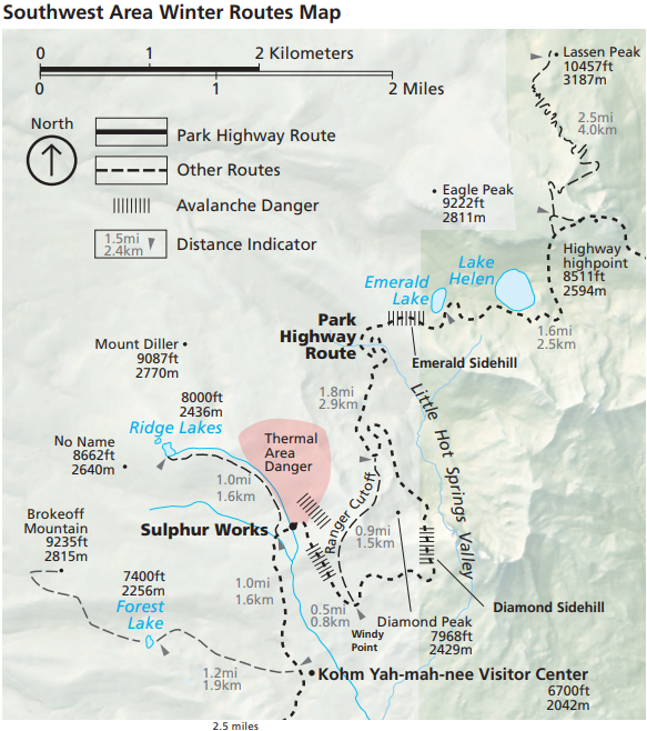
Sulphur Works –
- Distance: 2 miles round-trip
- Elevation: 6,700 to 7,000 feet
- Average Skiing Time: 1 hour
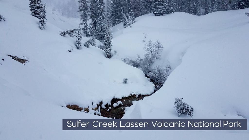
The boiling mudpots and steam vents at Sulphor Works are active year-round. Follow the park
highway route northwest from the southwest parking area. The left side of the route is bordered by steep side hills, be aware of avalanche danger. For your safety, do not travel or camp in or near hydro thermal areas. The snow surrounding these areas may look solid, but may actually be a weak snow layer hiding pools of acidic boiling water. Traveling too close to hydro thermal areas has resulted in severe injuries for previous visitors.
Nanny Creek via McGowan Ski Trail
- Located in adjacent Lassen National Forest
- Distance: 5 miles to Nanny Creek one-way
- Elevation: 6,080 to 5,110 feet
- Average Skiing Time: 4 hours
The McGowan ski trail is located in Lassen National Forest, 3.5 miles south of the southwest
entrance. Marked routes travel across a flat and slightly descending landscape. Follow a loop to
the north or ski through to Highway 36 at Nanny Creek. The trail does not go to McGowan Lake,
which is on private property. This main route makes for a good one-way ski route if vehicles are
available for shuttle.
Intermediate Routes
Ridge Lakes
- Distance: 4 miles round-trip
- Elevation: 7,000 to 8,000 feet
- Average Skiing Time: 4 hours
Follow the park highway route from the southwest parking area about ¾ mile and cross the bridge before Sulphur Works. The route begins at the north end of the flat area to the left. The route climbs rapidly along the east side of West Sulphur
Creek to the Ridge Lakes basin. Several good camping spots can be found on the north shore of
Ridge Lakes. If weather is severe, more protected camping can be found about ¼ mile below Ridge Lakes along its outlet creek. Avoid the area south of Ridge Lakes during periods of avalanche danger.
Mill Creek Falls
- Distance: 3.2 miles round-trip
- Elevation: 6,700 to 6,600 feet
- Average Skiing Time: 3 hours
This route is marked with tree markers, however the route is difficult to follow if you are unfamiliar with the summer trail. Travel east of the Kohm
Yah-mah-nee Visitor Center toward West Sulphur Creek. In about ¼ mile a bridge crosses the creek and should be avoided when snow-covered. The route climbs steeply before veering right (south) into the red fir forest. In another ¼ mile, the trail turns left (east) and continues through a series of rises and dips parallel to East Sulphur Creek. Two bridges cross above the waterfall and should be avoided during the winter season
Advanced Routes
Brokeoff Mountain
- Distance: 7 miles round-trip
- Elevation: 6,650 to 9,250 feet
- Average Skiing Time: 8 hours
Most skiers access the summit via the southwest ridge. Getting onto this ridge can be difficult as the various routes pass through hazardous canyons. Traditional routes use the Forest Lake route or the summer trail that begins near the park entrance. Numerous avalanche paths exist on all aspects of the mountain. Travelers should use extreme caution. Many skiers reserve travel on Brokeoff Mountain for spring when snow conditions traditionally stabilize. Summit conditions during inclement weather often include high winds with little or no visibility. Be cautious of overhanging cornices at the summit.
Lassen Peak
- Distance: 20 miles round-trip
- Elevation: 6,700 to 10,457 feet
- Average Skiing Time: 3 days
Most skiers and snowshoers allow three days to summit Lassen Peak in the winter. A possible
itinerary includes Lake Helen, summit Lassen, and return. Be prepared for high winds in the Lassen Peak and Lake Helen areas. Conditions on the mountain are most stable in early morning hours; afternoon travel is not recommended. The safest
route up the mountain follows the summer trail through the forested section and continues on the
southeast ridge to the summit. Weather conditions on Lassen Peak can deteriorate rapidly, creating white out conditions and high winds.
Manzanita Lake Routes
Beginner Routes
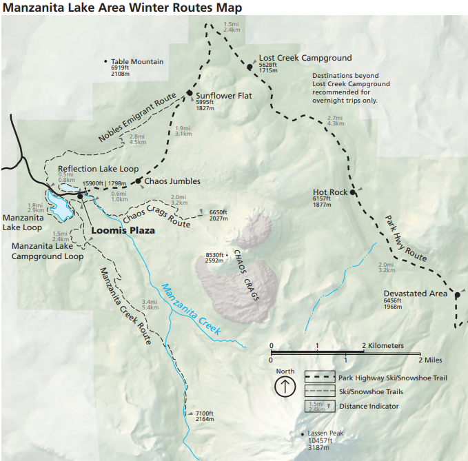
Manzanita Lake Winter Routes
Manzanita Lake Snowshoe Loop
- This trail is not recommended for skiing
- Distance: 1.5 mile loop
- Elevation: 5,800 to 5,850 feet
- Average Time: 1.5 hours
Begin near the Loomis Ranger Station and circle the lake in either direction. This route provides
excellent views of Lassen Peak and Chaos Crags. Please stay off lake ice, it is unstable and shores may be difficult to recognize under snow.
Manzanita Campground Loop
- Distance: 1.5 mile loop
- Elevation: 5,800 feet
- Average Skiing Time: 1.5 hours
Cross the footbridge by the Loomis Ranger Station, turn right and follow the road to the
campground for approximately a quarter mile to where it turns to the right through a set of large
rocks. The trail covers a half-mile loop through several sections of the campground.
Reflection Lake Route
- This trail is not recommended for skiing
- Distance: 0.5 mile loop
- Elevation: 5,800 feet
- Average Time: 30 minutes
Begin at the shore across the highway from the Loomis Museum and circle the lake in either
direction. It may be necessary to follow the park highway for a short section of the lake edge closest to the road. Please stay off lake ice, it may be unstable and shores can be difficult to recognize under snow.
Intermediate Routes
Chaos Jumbles Area
- Distance, elevation gain and times vary
Head up the park road for approximately a halfmile to an open area of stunted trees. Veer to the
right up toward Chaos Crags. Here the undulating topography slopes up into the bowl of the Crags. The terrain is easy to moderately difficult with excellent views at the higher elevations.
Chaos Crags Trail
- This trail is not recommended for skiing
- Distance: 4 miles round-trip
- Elevation Gain: 5,290 to 6,650 feet
- Average Time: 3-4 hours
Cross the footbridge by the Loomis Ranger Station, turn left and follow the road to the
Chaos Crags Trailhead sign. Follow yellow tree markers as the trail climbs steeply up to a ridge. If you decide to descend to Crags Lake, beware of potential rock falls and high winds.
Nobles Emigrant Trail
- Distance: 7 miles round-trip
- Elevation Gain: 5,875 to 6,275 feet
- Average Skiing Time: 3-4 hours
Pick up the trail north of Reflection Lake or at the trailhead off a service road west of Reflection
Lake. Follow the orange tree markers along the base of Table Mountain. The trail climbs over a
flank of Table Mountain into a thick fir forest and rejoins the park highway three miles east of the
Loomis Plaza at Sunflower Flat. Return the way you came or via the park road to make a loop.
Manzanita Creek
- Distance: 7.5 miles round-trip
- Elevation: 5,850 to 7,400 feet
- Average Skiing Time: 6 hours
From the Loomis Ranger Station, cross a footbridge, then turn right onto the Manzanita
Lake Campground road. Travel through the campground to the Manzanita Creek trailhead
sign. The route is mostly a gradual climb of approximately 1,000 feet. Beware of avalanche
chutes off of Loomis Peak that may reach the upper end of the trail.
Of course if you are heading into a back country type environment you want to be aware of winter safety in the area. Lassen Volcanic National Park provides this Avalanche Terrain Map for download and an Avalanche Awareness guide for your planning.
We at Sierra REC will be adding Lassen Volcanic National Park Snowshoeing to our Winter REC bucket list. The Park is 3-4 hour drive from Carson City up HWY 395 through Susanville Ca. and then over on Ca-44. Winter road Conditions can be checked on Caltrans or through Lassen’s Webcam network. We hope that you will find these guide helpful. If you head out to Lassen for a snowshoe trip send us a photo or two of your trip at sierrrecinfo@gmail.com. We would love to share your adventure.

Leave a Reply